by
Clyde & Kathi Camp
Copyright (c) 2000 - 2006
[ Send us an email if you like the tour! ]
[ Note: this site was hacked by OhioBarnsdotcom in 2013 to sell thier products - please do not buy from them. Sorry it took so long for the site to be repaired. Also, I no longer live in the area and cannot confirm that the instructions are valid any longer.
Drive Careful while you're having fun. ]
If you are a covered bridge fan or simply just like to get out and see interesting scenery, this whirlwind tour can be done in a single day and will take you to, and in most cases through, every covered bridge in Bucks County, Pennsylvania. The bridges all date from the 1800's and each has its own unique countryside and local attractions. The tour involves a lot of twisty little roads because the bridges are, after all, off the beaten path and not really tourist attractions!
Even so, all of the bridges are accessible by car and most mini vans and there are numerous opportunities for lunch along the way. A summary of the bridge characteristics is found at the end of this web page. If you're a fan of covered bridges, it's really worth heading down the route. You'll see some truly fantastic examples of quaint woodland architecture, and the bridges themselves are something to marvel at - architectural history of a time long past.
For the most enjoyment, I recommend that you simply print out and follow the directions below. The directions have been tested, take into account scenic routes, erroneous maps and various long-term detours caused by Hurricane Floyd damage and do work when they are followed explicitly [ except for when roads are out due to local flooding or repair - then you're on your own! ]. You might want to take a good map along just in case, but leave it folded in the glove compartment unless you get really lost. Otherwise, trust the directions and think about this as a sort of one day combination scavenger hunt and road rally.
In the following description (RO) means reset your trip odometer and start measuring miles from that point. If you don't have a trip odometer, well .... then you'll just have to use the regular odometer and do some addition in your head. If you get totally lost - that's what the emergency map is for.
Note:
- Clicking on the picture of the bridge will bring up some additional views of it that I have taken.
- Clicking on the name of the bridge will bring up info from another site owned by Mike MacCarter including additional photos, specifications and a map (in case you only want to go see a single bridge).
You begin your adventure (and end it, about 120 miles later) at Old Exit #30 from I-95 in Pennsylvania.
Then .....
| After exiting I95, reset your odometer (RO) and take PA 332 West towards
Newtown. Follow West 332 for 4.5 miles until it turns into Swamp
Road at the stop light. (North 413 will curve to the right but you should
continue straight on Swamp).
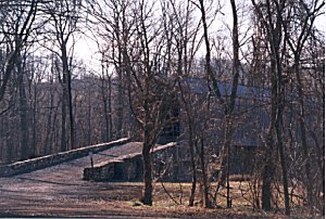
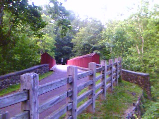
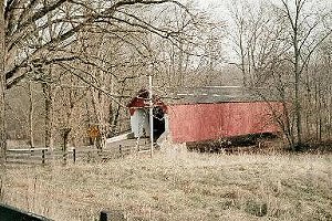
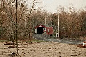
(RO) Follow Swamp Road for 1.6 miles and turn left on the dirt road at the Schofield Ford Bridge sign. Continue 0.2 miles on to the parking lot, park and then take the trail by the Covered Bridge Trail sign. The Schofield Ford Covered Bridge (also known as the Twining Ford Covered Bridge)is about 300 yards down the trail - keep to the left whenever the trail forks. |
|
|
Get back in your car and return to Swamp Road, turning right and retracing
your path to the PA 332/413 junction.
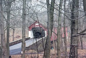
(RO) Turn left at the junction, following the signs for PA 413 North. Follow 413 North 3.5 miles to the PA 232 intersection. Note: On the way you will pass the In & Out Winery on the right at 1.3 miles and Carousel Village on the left at 2.5 miles. (RO) Turn right on 232 and follow it 5.9 miles to PA 32 (River Road) where you will turn right. (RO) Follow PA 32 south, paralleling the Delaware River and Delaware Canal, for 2.3 miles. After passing Washington Crossing State Park, turn right on Lurgan Road at the Bowman Hill Tower sign. Note: A slight detour to Bowman's Tower will give you a great 360 degree view of Buck's County if the weather permits. (RO) Turn right onto VanSant Road at 1.4 miles (you will pass the turnoff to Bowman's Tower at 0.6 miles). Follow VanSant Road for another 0.5 miles to the Van Sant Covered Bridge. |
| Continue through the Van Sant Bridge (RO) and continue on Covered Bridge
Road for 1 mile until you reach Aquetong Road.
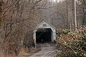
(RO) Turn left onto Aquetong and watch out for the fork at 1.2 miles where Aquetong goes left. At Carversville (7.5 miles) you'll hit a major (permanent?) detour. Turn left onto Carversville Road and then after about 50 yards, take the first right onto Wismer Road. (RO) Wismer will curve back and then climb a steep hill. Continue on for 3.5 miles until you come to Stump Road. (RO) Cross Stump Road, still on Wismer, and continue 1.0 miles to the Loux Covered Bridge. |
|
|
Continue through the Loux covered bridge (RO) and go up the hill 0.5
miles to the stop sign. The road sign says you're on Carversville road - evidently it changed name after going through the Loux Covered Bridge because on the other side of the bridge it's Wismer.
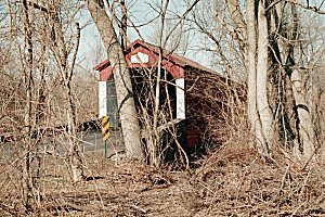
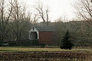
(RO) Turn right onto Dark Hollow Road and go 0.9 miles where the road makes a sharp left at the river. Instead of following Dark Hollow to the left, turn right onto Covered Bridge Road (RO) and enjoy the drive along the river for 0.6 miles to the Cabin Run Covered Bridge. Note: Ralph Stover State Park and the Stover-Myers Mill Park are now behind you. |
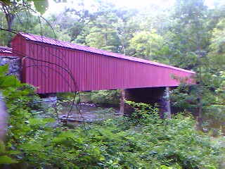
| Turn around and backtrack on Covered Bridge Road to the stop sign at Dark Hollow Road. (RO) Continue straight ahead on Dark Hollow and follow the road approximately 1 mile and turn right onto Stover Park road. (RO)The Pony Truss foot bridge crosses over Tohickan after about 1.3 miles. This is a boxed bridge (no roof) so it really isn't a covered bridge. But it's a very pretty bridge and I've included it on the tour since it's so close. [Photos by Tim Young] |
| Turn around and backtrack on Stover Park road until you get to Dark Hollow Road again.
(RO) Turn right onto Dark Hollow and continue 2.0 miles to Cafferty Road on the left. Careful! Cafferty Road is kind of hidden and slips up on you. There will be a brown stone house on your left). Note: There are some great views across the valley throught the trees to your left. (RO) Turn left onto Cafferty Road and go 0.6 miles down a steep incline to the Frankenfield Covered Bridge. |
|
|
Go through the Frankenfield bridge (RO) and up the hill 0.2 miles.
(RO) Turn right onto Hollow Horn Road and go 1.3 miles to the stop sign. (RO) Turn right onto Headquarters Road and go 1.0 miles to the stop sign (be sure to stay to the left when the road splits at the curve). (RO) Turn left on to Geigel Hill Road and go 0.2 miles to the Erwinna Covered Bridge. Note: Tinicum Park and the Erwin Stover House are nearby on Rt. 32. |
| Turn around and backtrack on Geigel Hill Road to where you turned onto
it from Headquarters Road.
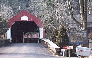
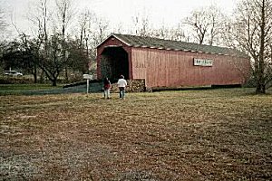
(RO) Continue on Geigel for another 0.3 miles to the stop sign at Rt. 32. Note: After about 0.1 miles, you'll cross the Delaware Canal. There's a nice little picnic place here. (RO) Turn left onto Rt. 32 (River Road) and go 1.7 miles to Uhlerstown Hill road. Note: There's a great little restaurant, The Bucks Bounty, on Rt. 32 at about 1.0 mile (RO) Turn left onto Uhlerstown Hill Road and go 0.3 miles to the Uhlerstown Covered Bridge. You can drive over the bridge, but can't go anywhere when you get to the other side. |
|
|
Turn around and backtrack Uhlerstown Hill Road to Rt. 32.
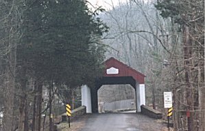
(RO) Turn left on Rt. 32 and continue following the Delaware River and Delaware Canal 7.9 miles to PA 611. Note: At 2.1 miles is the Delaware Canal State Park Office and at 7.1 miles is a small park at Lock #20 of the Delaware Canal Northbound 32 may have a major detour just before you get to the Indian Rock Inn. Take it and pick up 32 again on the other side of the detour. (RO) Turn right on 611 and go 1.7 miles to PA 212. Note: At this junction there is a small park at Lock #21 of the Deleware Canal. (RO) Turn left onto West 212. At 1.8 miles you will pass Durham Furnace. At 4.4 miles, the road will merge with North PA 412. Continue straight (Do not turn onto South 412) for another 1.8 miles (to odometer 6.2) where 412 and 212 split. Continue straight on West 212 for another 1.2 miles (odometer 7.4). (RO) Turn left onto Slifer Valley road and continue 1.2 miles to Knecht's Bridge Road and turn right through the Knecht's Covered Bridge. |
| After passing through the Knecht's bridge (RO), continue on for 0.1
miles and take the first right onto unpaved Springhouse Lane.
(RO) Continue on Springhouse 0.9 miles (slowly - it's unpaved, remember?) and turn right on Township Road, following it until you run into 212 again after about 1 mile. West 212 isn't marked, but the Trinity United Church of Christ is on the left. (RO) Turn left onto West 212 and follow it 0.4 miles until Bridge Street. Turn left on Bridge Street for 100 yards and then right onto Old Bethlehem road. (RO) Take Old Bethlehem Road and go 4.3 miles to Thatcher Road. Turn right at the La Campagna pizza place (it used to be the Parkway Restaurant) onto W.Thatcher road. (RO) Continue on W.Thatcher for 0.5 miles and turn left onto Covered Bridge Road. Continue on for 0.3 miles to the Sheard's Mill Covered Bridge. |
|
|
(RO) Go through the Sheard's Mill bridge for 0.5 miles to Richlandtown
Road.
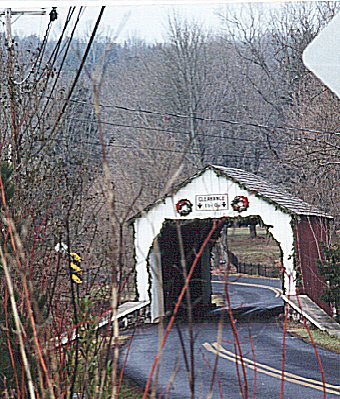
(RO) Turn left on Richlandtown Road and go 1.2 miles to Sterner Mill road. Turn left on Sterner for a hundred yards and then right on PA 563. (RO) Follow 563 0.9 miles and turn left onto East PA 313. (RO) Go 2.0 miles to Branch Road and turn right. (RO) Go 1.6 miles and pass Blooming Glen Road on the left. Continue another .1 miles and turn right onto the other Blooming Glen Road. Mood's Covered Bridge will be in front of you. The original bridge was arsoned on June 21, 2004 and all of the photos are of the original bridge before it was rebuilt in 2008. It is now one way only from Branch Rd. to 5th St. but these directions still work since that's the way the tour runs. |
| Cross over what used to be Mood's bridge and continue up the hill to the stoplight
on 5th Street in Perkasie.
(RO) Turn left at the light, continue on 5th for 1.4 miles and turn left at the Walnut Street light. (There's a oneway sign to the right here, but it only applies if you're turning right - it'll make sense when you see it.) The South Perkasie Covered Bridge is located about 0.2 down Walnut in a small park on the right. |
|
|
Turn right onto Walnut leaving the park, cross over Perkiomen Creek.
Continue straight through the first light (RO) and follow South PA 152. Note:
The Perk Eatery at 0.5 miles (est. 1854) has a great menu if you want to
stop. After 4.4 miles it will curve to the right and at
4.7 on the odometer, South 152 will turn left. Don't take Hilltown Pike
which goes straight!
(RO) After turning onto 152, follow it for 1.6 miles to New Galena Road, where you will again turn left. (RO) Follow New Galena for 0.7 miles until Peace Valley County Park and then turn right onto Callowhill Road. (RO) Follow Callowhill road 0.8 miles and turn left onto Ferry Road at the second stop sign. (RO) Follow Ferry Road for 0.4 miles and then turn right onto Old Iron Hill road. The Pine Valley Covered Bridge is about 0.4 miles further on at the bottom of the hill. |
This ends the tour. To get back to where you started, go through the Pine Valley bridge (RO) and continue straight (the road name arbitrarily changes to Keeley Avenue). At the first stop sign, cross Sioux and continue left on Keeley for .5 miles until you hit E. Butler (PA 202.)
(RO) Turn left on North 202 and follow it to 1.5 miles to the Doylestown bypass. You can either take the North 202 Bypass to the right around Doylestown or go straight onto State Street which takes you through historic downtown Doylestown and merges with the bypass on the other side. Whichever way you take, you will come to a stoplight at the junction of 202 and 313.
(RO) Continue on 202 to Buckingham for 2.4 miles where you pick up PA 413 South.
(RO) Follow 413 South. Note: at 2.2 miles you will pass the Buckingham Valley Vinyard on the left. At five miles, 413 will cross 232.
Yes, this should look familiar because you went by here on the way to the Van Sant Bridge earlier in the day. From this point on, you are backtracking to I-95. Cross 232 and continue on 413 South. At 9.1 miles, 413 will jog to the right and then back to the left after a couple of hundred yards. Continue following South 413 until it merges with East PA 332. Then follow East 332 until mile 14.2 and you will be at the I-95 junction you started out on.
# |
Built |
Limit |
Limit |
|||||
| Schofield Ford (also known as Twining Ford) |
1873
(1997) |
13 ft | 170 ft | 16 ft | No Vehicle Access | Neshaminy Creek, Tyler State Park off Swamp Road, Newtown Twp. | Originally built in 1873, burnt down in 1991 and rebuilt in 1997. Built of native hemlock and oak, this town truss bridge is the longest in Bucks County. | |
| Van Sant (also known as Beaver Dam) |
1875 | 12 ft 6 in |
86 ft | 15 ft | 7 tons | Pidcock Creek, Covered Bridge Rd., Solebury Twp. | Close to Bowman's Hill and the Thompson-Neely House, part of Washington Crossing Historic Park. | |
| Loux | 1874 | 11 ft | 60 ft | 15 ft | 15 tons | Cabin Run Creek, Wismer Road, Plumsted Twp. | Made of hemlock, nestled in a scenic Valley, this bridge is one of two that span Cabin run Creek. | |
| Cabin Run | 1871 | 11 ft 10 in |
82 ft | 15 ft | 3 tons | Cabin Run Creek, Covered BridgeRoad, Plumsted Twp. | Located a short way downstream from the Loux Covered Bridge | |
| Frankenfield | 1872 | 11 ft 3 in |
130 ft | 12 ft | None | Tinicum Creek, Hollow Horn & Cafferty Road, Tinicum Twp. | Crosses Tinicum creek only two miles upstream from where the creek flows into the Delaware River. One of the longest covered bridges in bucks County. | |
| Erwinna | 1871 (1832?) |
11 ft | 56 ft | 15 ft | 29 tons | Lodi Creek, Geigel Hill Road, Tinicum Twp. | Although the National Historic Register lists the construction date as 1871, the county records suggest it was acutally built in 1832. It is a good example of the lattice-type construction and is Bucks County's shortest covered bridge. | |
| Uhlerstown | 1832 | 11 ft 3 in |
101 ft | 15 ft | None | Delaware Canal, Uhlerstown Road, Tinicum Twp. | Built of Oak, the bridge has windows on both sides and is the only covered bridge that crosses the Delaware Canal. | |
| Knecht's (also known as Slifer's Bridge) |
1873 | 11 ft 6 in |
110 ft | 15 ft | 3 tons | Durham Creek, Knecht's Road, Springfield Twp. | Built of Hemlock, the bridge crosses Durham Road which was once known as Cook's Creek. | |
| Sheard's Mill | 1873 | 12 ft 1 in |
130 ft | 15 ft | None | Tohickon Creek, Covered Bridge Road | Located between the Haycock and E.Rockhill Twps it is tied with the Frankenfield covered bridge as the longest in Bucks County | |
| Mood's | 1874 | 11 ft 2 in |
120 ft | 15 ft | None | Perkiomen Creek, Blooming Glen Road, E.Rockhill Twp. | One of two covered bridges in the town of Perkasie, Mood's covered bridge crosses one of the principal watersheds in the northeast portion of Bucks County. Bridge and crossing were destroyed by arson in 2004. A new ugly, non-covered bridge was built on the roadbed of the covered bridge. The Moods Covered Bridge was rebuilt in 2008. It is now one way only from Branch Rd. to 5th St | |
| South Perkasie | 1832 | No Vehicle Access | 93 ft | 15 ft | No Vehicle Access | Lenape Park, Walnut St., E.Rockhill Twp | Built of Pine and Oak, the bridge once crossed Pleasant Spring Creek until traffic was prohibited. | |
| Pine Valley (also known as Iron Hill Bridge) |
1842 | 11 ft 10 in |
81 ft | 15 ft | None | Pine Run Creek, Old Iron Hill Road, New Britain Twp. | Built of native Hemlock and Pine, the bridge crosses the Pine Run Creek, named after the local pine trees. | |
| Pony Truss | ?? | ?? | ?? | ?? | Across Tohickon Creek in Ralph Stover State Park | Now on the tour based on info from Tim Young who confirmed that it is still there as of 2008 and provided these photos (1 & 2). Not on many brochures or maps of bridges in Buck's County. |